State And Municipal Appendix Materials
This page contains the state and municipal level data and analysis materials relevant to Technical Paper 167: Vulnerability of Municipal Transportation Assets to Sea Level Rise and Storm Surge. While all the material presented below are extremely pertinent to understanding the exposure and vulnerability of municipal transportation assets to sea level rise and storm surge, presenting them bundled together would have become unwieldly in a paper format and would have been difficult to navigate in a PDF. Those interested in getting the most out of the Vulnerability of Municipal Transportation Assets to Sea Level Rise and Storm Surge project should browse the included materials and download the PDFs most pertinent to their geographic area.
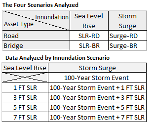
The materials in this appendix identify the transportation infrastructure at risk under one, three, five and seven feet of sea level rise, and also analyzes how these sea level rise scenarios would interact with a 100-year storm surge event. For the purposes of this paper, “transportation infrastructure” may include all state or municipally owned roads and bridges in Rhode Island. Since sea level rise and storm surge are distinct, albeit related, phenomenon, two scenarios were required to analyze these phenomenon. Since roads and bridges are very different kinds of assets, separate scenarios were also required to analyze these assets. As a result, each* of the following data packets includes materials for four analysis scenarios, subdivided by inundation type and asset. Each data packet includes a map and a table for each scenario.
*The town of Little Compton is presented with only two scenarios. Because there are no bridges of 25 Ft or more in the town that are exposed to either sea level rise or storm surge, the scenarios involving the analysis of bridges were omitted due to lack of data.
Appendix I consists of a PDF document providing a detailed explanation of the vulnerability assessment methodology, expanding on the discussion included in the text of Technical Paper 167. Beyond simply describing the process, the appendix provides the numeric assignments and weights used in the assessment, and a fully worked through example.
Those interested in issues affecting Rhode Island as a whole, or interested in comparing their city or town’s situation to a wider baseline, would be well served to download the statewide data packet. This data packet includes maps and tables for the entire State of Rhode Island. The maps are large format (size E) PDF maps of all areas in Rhode Island exposed to sea level rise and storm surge. The tables list all assets exposed to sea level rise or storm surge, ranked by vulnerability from highest to lowest. To learn more about the vulnerability scoring system, please refer to the main text of Technical Paper 167: Vulnerability of Municipal Transportation Assets to Sea Level Rise and Storm Surge. There is one map and one table for each of the four analysis scenarios.
The statewide data presented above has been subdivided by municipality for the convenience of those interested in a more restricted geographic area. The municipal data packets include maps and tables containing information pertinent to the municipality in question. The maps are large format (11x17) PDF maps of each municipality exposed to sea level rise and storm surge. The tables list all assets exposed to sea level rise or storm surge, ranked by vulnerability from highest to lowest. To provide context the tables also include each asset’s state vulnerability rank. To learn more about the vulnerability scoring system, please refer to the main text of Technical Paper 167: Vulnerability of Municipal Transportation Assets to Sea Level Rise and Storm Surge. There is one map and one table for each of the four analysis scenarios.
To access the municipal data packets, please utilize the links below. By clicking on the city or town of interest, the user will be able to download a PDF containing the data packet for that municipality.