Statewide Transportation Assets
Rhode Island faces the challenge of adapting to sea level rise in our coastal communities. These changes will affect our state’s transportation network, and the more proactive we can be about identifying vulnerabilities, the greater chance we have to make wise decisions about our investments in transportation infrastructure. This project takes the first step by allowing the state, its cities and towns, and its residents to learn more about the infrastructure most likely to be inundated under various sea level rise scenarios.
To be consistent with other projects on SLR in Rhode Island, we selected three scenarios to analyze on top of the average daily high tide; also referred to as Mean Higher High Water (MHHW): 1 foot of SLR, 3 feet of SLR, and 5 feet of SLR. Given these scenarios, we examined the exposure of transportation infrastructure, including roads, rail, bike paths, ports & harbors, RIPTA bus routes, intermodal hubs, and bridges to ocean water. The sea level rise scenarios are based on current conditions and do not include projections of erosion, storm surge, or precipitation.
This project provides an overview for state, local staff, and the public of the exposure of our transportation assets to SLR inundation and helps transportation stakeholders with estimations of the exposure of specific assets.
This will be a useful resource in providing an overall understanding of key transportation system exposures, resources for state DOT and local DPWs and to foster conversation on how we prioritize efforts to manage the impacts of sea level rise.

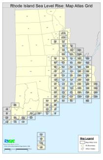
Maps
| A5 | B5 | C5 | D5 | G1 | G2 | G3 | H1 | H2 | H3 | H4 | I1 | I4 |
| I5 | I6 | I7 | J1 | J6 | J7 | K2 | K6 | K7 | L6 | L7 | L8 | L9 |
| L11 | M7 | M8 | M9 | M10 | M11 | M12 | N7 | N8 | N9 | N10 | N11 | N12 |
| O7 | O8 | O9 | O10 | O11 | O12 | P7 | P8 | P9 | P10 | P11 | P12 | Q7 |
| Q8 | Q9 | Q10 | Q11 | R7 | R8 | R9 | R10 | R11 | S7 | S8 | S9 | S10 |
| S11 | T7 | T8 | T9 | T10 | T11 | U7 | U8 | U9 | U10 | U11 | V7 | V8 |
| V9 | V10 | V11 | W8 | W9 | W10 | X8 | X9 | X10 | Y8 | Y9 | Z7 | Z8 |
| AA8 | AB8 |
