Municipal Transportation Assets
Sea level rise and the gradual increase in high tides have been occurring for decades. International, national, and Rhode Island-based experts agree that the rate of sea level rise will increase by the end of the century. Sea level rise presents a major challenge to Rhode Island’s transportation infrastructure, both via daily tidal flooding of coastal assets and by making storm surge events more severe. The latest estimates of the scientific community are that Rhode Island could experience up to 7 feet of sea level rise by the end of the century. During that same time period Rhode Island can expect at least one 100-year storm surge event, an event whose severity will potentially be magnifies by sea level rise.
Technical Paper 167: Vulnerability of Municipal Transportation Assets to Sea Level Rise and Storm Surge presents data and analysis detailing the impact of sea level rise and storm surge on Rhode Island’s transportation infrastructure. Municipal and state leaders, policy makers, and practitioners will be able to utilize this data and analysis to prepare the state for the challenges posed by sea level rise and storm surge. In addition to explaining and presenting the data, the technical paper provides a brief outline of strategies that may help in adapting to these conditions, and point towards resources that will enable further investigation.
Relevance
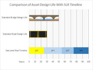
The impacts of Sea Level Rise (SLR) are often perceived as distant, but the assets being built today will still be within their design life when future effects of sea level rise are felt. In addition, sea level rise will magnify the impacts of 100-year storm surge events by raising the water level. Though current federal guidelines only require federally funded assets be built to survive a 100-year storm event, the impact of a 100-year storm event is likely to change during the design life of the assets currently under consideration in Rhode Island.

The analysis presented in the Vulnerability of Municipal Transportation Assets to Sea Level Rise and Storm Surge project shows that in Rhode Island 1.9 miles of roadway are expected to flood at high tide under one foot of sea level rise, 34 miles of roadway at three feet of sea level rise, 102 miles of roadway at five feet of sea level rise, and up to 175 miles of roadway at seven feet of sea level rise. Additionally, 81 bridges may be affected by the projected sea level rise. Under current conditions, a 100-year storm surge event would flood up to 337 miles of roadway. With one foot of sea level rise a similar event would flood 373 miles of roadway, three feet of sea level rise would see 436 miles flooded, five feet would cause 505 miles to flood, and seven feet would see 573 miles flood in the event of a 100-year storm event. 163 bridges would potentially be affected under these combined sea level rise and 100-year storm event conditions
Background and Objectives
The analysis presented in Technical Paper 167 follows up on a similar, prior technical paper entitled “Technical Paper 164: Vulnerability of Transportation Assets to Sea Level Rise.” The prior paper piloted a methodology for analyzing sea level rise vulnerability by focusing on assets under state jurisdiction. The new paper (Technical Paper 167: Vulnerability of Municipal Transportation Assets to Sea Level Rise and Storm Surge), seeks to follow up on those prior efforts by utilizing additional data, including storm surge modeling, and focuses on municipal assets in order to help the cities and towns of Rhode Island prepare for sea level rise and storm surge in their local planning efforts.
In addition to the new data, the project seeks to improve the communication of this data and analysis to municipal level stakeholders. This web site was created to ensure that this analysis is communicated clearly to as wide an audience as possible.
Exposure and Vulnerability Analysis

To help Rhode Island’s cities and towns prepare for these changing conditions, the Statewide Planning Program (SPP) has engaged in an effort to analyze the potential impacts created by sea level rise and storm surge. Using data developed under the name “STORMTOOLS” by the Coastal Resources Management Council and the University of Rhode Island, SPP identified the assets that could be impacted (exposure), and their vulnerability. As a result of this analysis, SPP identified the roads and bridges most likely to be impacted by Sea Level Rise, and scored their relative vulnerability based on the severity of the hazard they face and the potential impact of asset damage on the transportation system as a whole.
Project Materials
There are several ways to begin exploring the data in the Vulnerability of Municipal Transportation Assets to Sea Level Rise and Storm Surge project. Municipal officials, staff, or residents may wish to begin with the fact sheets prepared by the Statewide Planning Program that provide straightforward information pertinent to each municipality, along with a high level summary of the methodology and next steps.
For those who are looking for a more detailed examination of the data see, Technical Paper 167: Vulnerability of Municipal Transportation Assets to Sea Level Rise and Storm Surge. Please note that due to the extensive data involved, Technical Paper 167 is presented with an abbreviated appendix.
Practitioners and municipal officials who want to access the full data sets utilized by the Vulnerability of Municipal Transportation
Assets to Sea Level Rise and Storm Surge project should access the state and municipal appendix materials. This expanded appendix presents the full set of state and municipal materials compiled in the creation of Technical Paper 167: Vulnerability of Municipal Transportation Assets to Sea Level Rise and Storm Surge. The appendix includes the full set of large format maps and tables for all transportation assets in The State of Rhode Island, and a geographic interface allowing users to access the full set of large format maps and tables for each of the 21 coastal communities in Rhode Island.

