Active Transportation Technical Assistance
Multi-Modal Planning for Safety and to Increase Transportation Alternatives
In 2017, the Division of Statewide Planning launched a local planning technical assistance program for municipalities that emphasizes active transportation planning. This program aims to increase multi-modal opportunities by increasing trips using a mode other than single occupant vehicles, as well as the planning for the infrastructure to support non-motorized trips. Planning for sidewalks, bike lanes, bike paths, crosswalks, bus shelters, transit hubs, and bike or scooter share programs falls under this definition of active transportation.
What We Do
The program is designed to respond to a municipality’s specific transportation planning priorities and needs. Assistance may focus on master planning, corridor planning, broader systems-based strategies, long- and short-range plans, existing conditions analysis, infrastructure analysis, and conceptual designs.
Assistance provided for studies/plans of
- Traffic calming
- Streetscape design
- Safety improvements
- Accessibility improvements
- Bike facility amenities
- Transit facility amenities
- Increasing mobility choices
- Promoting walkability and bike-ability of neighborhoods
- Improving access to jobs, retail, services, etc.
- Supporting existing businesses, attracting new businesses
How the Program Works
The Active Transportation Technical Assistance is structured as a partnership.
- RIDSP and the municipality collaboratively define the project scope
- RIDSP manages procurement and hires the consultant
- RIDSP funds and administers the contract
- Depending on the funding source, municipalities may provide match of in-kind staff time and/or cash.
- Municipal staff actively guide priorities and outcomes
- Regular coordination meetings ensure strong collaboration
This approach allows communities to access technical expertise while maintaining local ownership of the process and results.
Interested in Applying?
Active Transportation Technical Assistance is offered on a competitive basis. If your community is interested in addressing comprehensive transportation planning for safety and multi-modal enhancement, we encourage you to contact RIDSP to discuss potential project ideas.
For more information about the Division of Statewide Planning’s Active Transportation Technical Assistance program please contact Assistant Chief, Roberta Groch, AICP at 401-222-4720 or Supervising Planner Josh O’Neill, AICP at 401-222-4849.
In January of 2026 the Division of Statewide Planning kicked off new local technical assistance planning project with the Town of Lincoln focused on conceptual redesign of specific corridors within the neighborhoods of Saylesville and Lonsdale. The Saylesville and Lonsdale neighborhoods of Lincoln currently face several significant issues that compromise safety and accessibility. The right-of-way along several local roads are overly wide which encourages speeding, and the sidewalks are in extremely poor condition, which discourages pedestrian use. Additionally, in Saylesville the intersection with Chapel Street and Walker Street is notorious for accidents and near misses, with high vehicle speeds contributing to the frequency of these incidents. Several local roads are used as cut throughs, adding to pedestrian and bike safety concerns.
The study will improve pedestrian access and safety in an area of Lincoln with significant existing and planned residential and mixed-use development. It will also create much-needed connections to existing recreational and transportation assets, such as Lincoln Woods State Park, the Blackstone River Bike Path, and major roadways connecting Lincoln to neighboring communities.
Lincoln Study Area – Project Corridors

For more information about the Division of Statewide Planning’s Active Transportation Technical Assistance program please contact Assistant Chief, Roberta Groch, AICP at 401-222-4720 or Supervising Planner Josh O’Neill, AICP at 401-222-4849.
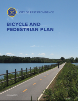
The City’s first Bike and Pedestrian Master Plan takes a comprehensive look at East Providence’s active transportation network, uses best practices and objective analysis to determine how public rights-of-way can be used to achieve City goals more effectively, and develops an implementation strategy that sets a clear and achievable path for future multi-modal investments. The Plan reflects the goals and objectives of Moving Forward RI 2050, the State’s Long-Range Transportation Plan. It is also consistent with the long-term vision and builds upon the guidance from the RI Bicycle Mobility Plan (2020).
This plan is designed to help East Providence become a community where people of all ages and abilities are safe and comfortable and can choose to walk, and bike to everyday destinations like schools, bus stops, grocery stores, parks, and jobs. Developed with support from the Rhode Island Department of Administration’s Division of Statewide Planning, this Plan reflects the vision of the people of East Providence, shared between the summer of 2024 and the autumn of 2025.
For more information about the Division of Statewide Planning’s Active Transportation Technical Assistance program please contact Assistant Chief, Roberta Groch, AICP at 401-222-4720 or Supervising Planner Josh O’Neill, AICP at 401-222-4849.
“Keep Newport Moving” is the City’s first mobility plan in over twenty years and provides comprehensive, actionable strategies to make it safer, easier, and more enjoyable for residents and visitors to navigate Newport’s historic street grid, no matter how they choose to move around the city. This Plan supports and is consistent with the broader goals of the City of Newport’s Comprehensive Plan and the North End Urban Plan (NEUP).
“Keep Newport Moving” sets a long-range vision for creating an equitable transportation system with access for all modes. The Plan supplements existing city goals for preservation, green and complete streets, sustainability, resiliency and equity in community and economic development.

The Plan included:
- Identifying road diets and two-way traffic conversions
- Analyzing truck routes and truck loading areas for improvement
- Matching parking demand and supply for all types of vehicles
- Encouraging through design, the use of walking and biking as viable means of transportation
- Solving gaps and barriers in the existing active transportation and transit networks
- Incorporating design guidance into city regulations
For more information about the Division of Statewide Planning’s Active Transportation Technical Assistance program please contact Assistant Chief, Roberta Groch, AICP at 401-222-4720 or Supervising Planner Josh O’Neill, AICP at 401-222-4849.
Developed in partnership with the neighboring Cities of Pawtucket and Central Falls, the vision for Bike/Walk PCF is to be safe and inviting places for all people to travel, whether on foot, by bike, by bus, or by vehicle. With the opening of the Pawtucket-Central Falls Transit Center and the start of MBTA passenger rail service to Boston in 2023, this plan also outlines how to make connections to this crucial area, as well as nearby areas of commerce, education, entertainment and recreation.


The technical assistance for this project was used to:
- generate maps for preferred bicycle routes
- conceptual plans for select routes (cross sections)
- creation of policy recommendations
- identification of measures of the greatest benefit
- prioritization of implementation strategies; and
- cost estimates for project implementation.
For more information about the Division of Statewide Planning’s Active Transportation Technical Assistance program please contact Assistant Chief, Roberta Groch, AICP at 401-222-4720 or Supervising Planner Josh O’Neill, AICP at 401-222-4849.